

23 Sep Hiking in Slovenia – Aljazev Dom – Kriz Peak
Slovenia is one of those countries to which we return time and time again and which each visit we discover something new and amazing. Even though it is not particularly large it has some fantastic landscapes that will charm you no matter the season. Hiking in Slovenia provides a large array of options out of which, for this trip we decided to go from Aljazev Dom (chalet) and hike to Kriz Peak, towering at 2410 meters.
Distance
15 Km
Total Time
11 h 00 min
Active Time
8 h 30 min
Vertical Relief
+1600 / -1600 m
Min/Max Altitude
995 – 2410 m
Average Speed
2.0 km/h
Hike to Kriz Peak
Even though we have been to Slovenia earlier this year for a bicycle trip this has not stopped us to plan a new mini holiday in this lovely country. We set out eyes on the hike to Kriz Peak, in the Triglav National Park, starting from Aljazev Dom (chalet). It has been years since we last hiked in the area so we were trilled to return. We spent our first holiday together in Slovenia and it just so happens that this hike was during our third year wedding anniversary. Double the joy, triple the excitement 🙂

This circuit brought us some stunning views. The starting point is the Aljazev Dom, a chalet situated at about 1000 meters altitude. The place also has a spacious parking lot for which you need to pay a few Euros per day. If it is full you will also find a few places along the road where you can park for free (you just need to walk a bit to the chalet).
From the hut we started the hike through the forest on a pretty demanding slope. The abundant vegetation demonstrates that rain is in no short supply here and today was no exception. Even though we studied this hike at home and knew the general details, length and vertical height of the circuit we started on the wrong foot:
Expectation:
Because the hike was only 15 km long we thought that it makes no sense to start out early. We should have enough time, what could go wrong? As such we woke up, had a late breakfast and by 11 AM we eventually started the trip. Karina even thought that we should be done by 5 PM. After which we could have dinner and maybe have a light run in the vicinity of the camping place.
Reality
As already said, we started the hike at 11 AM. On the hiking info board we read that the ascent should take us about 4 hours. The mountain was shrouded in a thick cloud. Because of the humid warm air our ascent was really slow. Don’t know why but for us the warm humid air in correlation to effort results in really bad performance.


Needless to say that all those fantastic views were no where in sight. The cloud restricted our view to a maximum of 20 meters. At one point we left the forest behind and entered the alpine planes, surrounded by a rocky landscape.
We reached a narrow valley with a steep slope that still had a consistent layer of snow. At points it was more than one and a half meters deep. We started on the right side and when the marking disappeared we follow the footpaths over the snow. This took us to the left side where we found the marking again. The rock is calcareous which still offers decent grip even when wet.
Slowly as we ascend we start seeing clear sky between the clouds. We hoped that we might even be above the cloud level. As we made progress we saw the mountain peaks around us.
Particularly curious is that there was a second level of clouds just above the peaks. Thoughts … maybe they will go away until we reach our destination?!
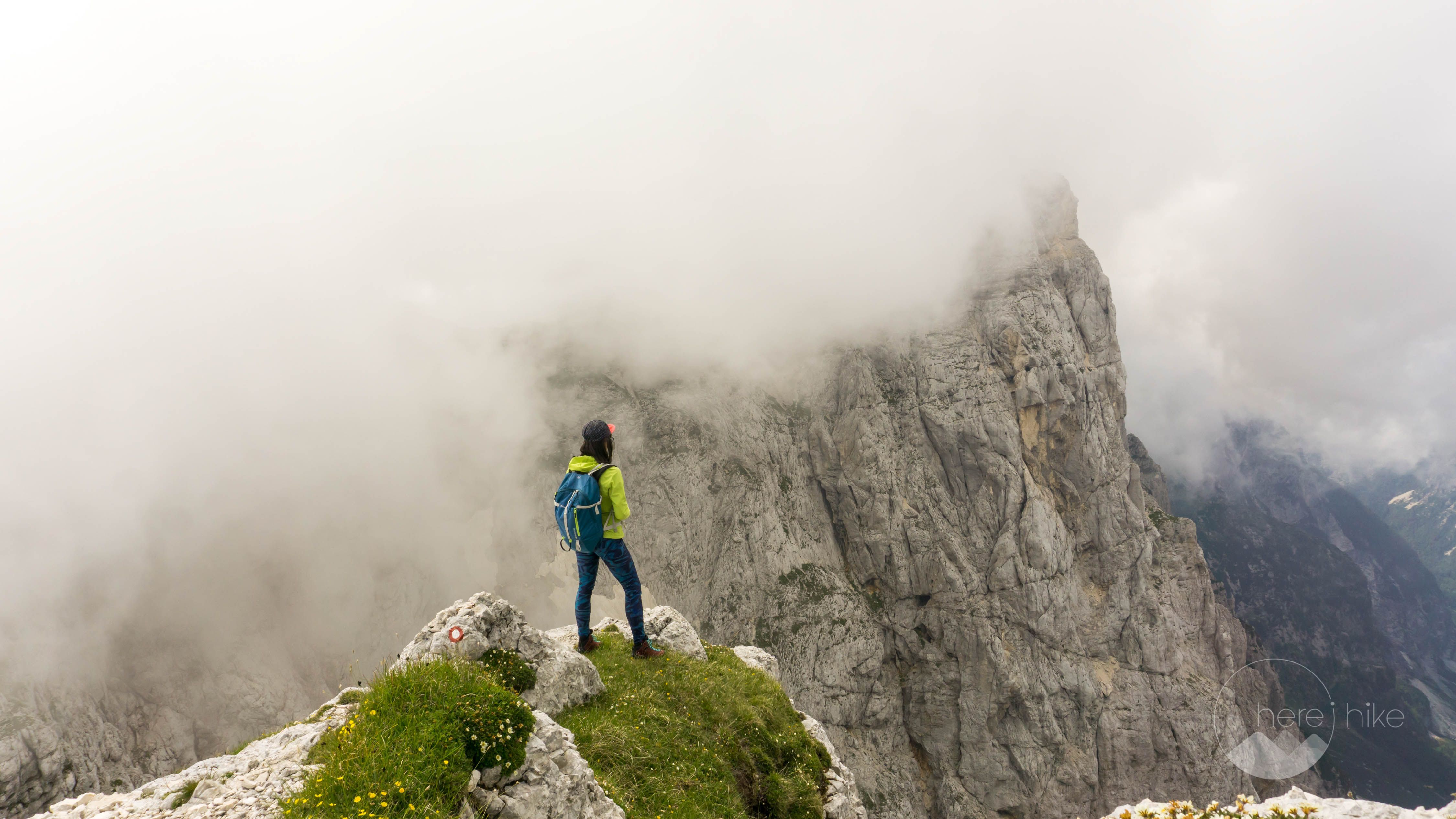
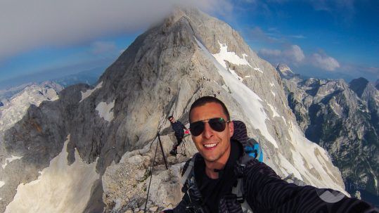
Up there the air is more breathable and the sights shifted our focus from our exhaustion. The footpath takes us to Bivak IV, a small and clean shelter, and continues towards the peak on the left side.
Then sun was playing games between the fluffy clouds as we were hoping that we might be lucky enough to catch for a few pictures on the summit.
The route until here was demanding, while the next section is lighter but on a bit more technical terrain. Nevertheless nothing too complicated, just a bit of scrambling, a few steel cables and a passage between two large rocks. Through the clouds we almost see our peak. We decided to wait a bit on the peak. We just need a few minutes cloud-free. Nevertheless, this didn’t happen and when the cold started kicking in we decided to descend.


Because our hike was a circuit we had no idea how the descent was going to look like. We just knew that on our way we would be passing by Pogacnikov Dom (chalet) and that we would stop for a coffee there. The descent would take us through Vrata Valley about which we read that it would be one of the most beautiful in the park.
On our way we found lots of Ibex goats that were curiously watching us. The high contrast between the rocky surroundings and the fresh green color of the grass made for a stunning view. Even though the clouds ruined our mountain top view they created some fantastic sights afterwards!
We stopped at the chalet for blessed cup of coffee. Even if it was already 6 PM, I was still thinking that the 6 kilometres we had left shouldn’t take us more than 2 hours, since it was all downhill. Karina’s plan for an evening run was crumbling as the knee pain was already starting to kick in. When we left the hut we saw a pole: ‘4 hours to Aljazev Dom’. What?!
All of a sudden the situation was not looking all that pink due to the late hour and the fact that we were tired. Where ever possible we ran. On top of it all an even more thick mist shrouded everything in sight. We were simply hoping to finish the descend as fast as possible, before nighttime, to avoid orientation problems. We did a short stop with a family of Ibex which we meet on the footpath, the young ones were very curious and came really close to us.
From there the descent turn into a painful adventure on gravel, snow and rock. At one point, out of sheer luck, through the clouds we saw Kredarica Chalet and Triglav Peak on the horizon. What a view!
The next section was descending through a narrow valley with snow, where we needed to jump from one side to the other. The chains were berried in snow so were of no use to us. All in all it ended well.
Next we entered the forest and from here the footpath takes you back to the chalet. In all it took us 3 hours instead of 4 to descend but we were dead tired. We had serious discussions if we should have dinner and shower or go directly to bed. We showered, skipped dinner and went for a well deserved sleep.
Moral of the story: don’t underestimate a trail. Other than that we had a great anniversary and some wonderful pictures 🙂


GPS track to Kriz Peak
How to get to Kriz Peak?
There is only one road that takes you to Aljazev Dom. you start of on an asphalt road but in short time this turn to gravel. The road is decent for most small cars. There is a large parking lot at the chalet that you need to pay for if you are not a guest.
Where to sleep?
If you plan to spend the night in your tent then one of the best places around is Camping Kamne. The place has its ups and downs. When we were the first time here we thought this was one of the best camping places ever (back then it was also in better shape), but now all we can say is that it is Ok.
The camping area are still really nice with soft grass. You have a place where you can eat, even if it rains and overall it is pretty clean (but could be a bit better). One of the negative sides is that there are not so many showers available and they are with coins / timer. This is not really all that bad except for the fact that the coin machine is outside of the shower cabin and you have no pause button or warning when your time is close to an end. As such, if you didn’t estimate your time correctly you need to open the door and get out to insert another coin. Even as such it still the best camping option in this area.
Good to know
There is no entrance fee for the park but there are some parking places that you need to pay.
Inside of the park camping is not allowed as well as wild fires. You can spend the night at one of the alpine chalets and most of them also serve food.
Check the weather forecast before stating your trip as you don’t really want to be in the middle of a storm. Also you can expect snow even in August on some valleys, it depends on how hard the previous winter was.


Hope you found the information helpful and accurate, but remember, if you have any questions drop them in a comment below!
Other great adventures
-

Hiking in Slovenia – Aljazev Dom – Kriz Peak
Slovenia is one of those countries to which we return time and time again and which each visit we di...
-
Bike Trails in Slovenia – Around Bled and Bohinj Lakes
Discover four road bike trails in Slovenia around the wonderful area of Bled and Bohinj lakes. Slove...
-
Hiking in Slovenia: Triglav Peak – This is Amazing!
The hike to Triglav peak will take you to the highest top in Slovenia and in the Julian Alps mountai...
Sorry, the comment form is closed at this time.